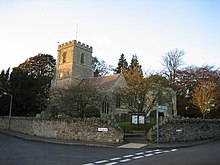
Steeple Aston
Human settlement in EnglandSteeple Aston is a village and civil parish on the edge of the Cherwell Valley, in the Cherwell District of Oxfordshire, England, about 12 miles (19 km) north of Oxford, 7 miles (11 km) west of Bicester, and 10 miles (16 km) south of Banbury. The 2011 Census recorded the parish population as 947. The village is 108 metres (354 ft) above sea level. The River Cherwell and Oxford Canal pass 1 mile (2 km) east of the village. The river forms part of the eastern boundary of the parish. The parish's southern boundary, 1⁄2 mile (800 m) south of the village, also forms part of Cherwell District's boundary with West Oxfordshire.
Read article
Top Questions
AI generatedMore questions
Nearby Places

Rousham House
Country house at Rousham in Oxfordshire, England

Upper Heyford, Oxfordshire
Human settlement in England

Lower Heyford
Human settlement in England

Heyford railway station
Railway station in Oxfordshire, England

Rousham
Village and civil parish in England
Middle Aston
Human settlement in England

Beeches Light Railway

Horsehay Quarries
Protected area in Oxfordshire, England


